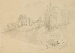
Unbekannt (20. Jahrhundert), „Oberplan“ im Böhmerwald, Blick in die Landschaft, 1938, Bleistift
- Technik: Bleistift auf Papier, montiert auf Papier
- Bezeichnung: Rechts unterhalb der Darstellung bezeichnet mit „Oberplan“. Horní Planá (deutsch ‚Oberplan‘) ist eine Stadt am Böhmerwald im südböhmischen Bezirk Krumau in Tschechien. Durch die Lage am nördlichen Ufer des Moldaustausees ist Horní Planá ein beliebter Ausflugsort.
- Datierung: 1938
- Beschreibung: Sehr schöne Ansicht von Oberplan. Adalbert Stifter schildert die geografische Lage der gerodeten Landschaft und die „herumgestreuten Dörfer“ in seiner Erzählung ‚Der beschriebene Tännling“: „Das Tal ist sanft und breit, es ist von Osten gegen Westen in das Waldland hinein geschnitten, und ist fast ganz von Bäumen entblößt, weil man, da man die Wälder ausrottete, viel von dem Überflusse der Bäume zu leiden hatte, und von dem Grundsatze ausging, je weniger Bäume überblieben, desto besser sei es. In der Mitte des Thales ist der Marktflecken Oberplan, der seine Wiesen und Felder um sich hat, in nicht großer Ferne auf die Wasser der Moldau sieht, und in größerer mehrere herumgestreute Dörfer hat. Das Tal ist selber wieder nicht eben, sondern hat größere und kleinere Erhöhungen.“
- Schlagworte: Adalbert Stifter, Adalbert Stifter Land, Landschaft, Stadtbilder, Tschechische Republik, Gegenständlich, 1925-1949
- Größe: 14,5 cm x 22,0 cm, Weitere Maße: Unterlage: 22 x 29,1 cm
- Zustand: Guter Zustand. Das Blatt ist altersbedingt leicht gebräunt und stellenweise stockfleckig; im oberen Bereich des Blattes und der Unterlage ist das Papier leicht gewellt, die Unterlage knickspurig. Die Darstellung macht einen sehr guten Eindruck.
English Version:
Unknown (20th century), „Oberplan“ in the Bohemian Forest, view of the landscape, 1938, Pencil
- Technique: Pencil on Paper, mounted on Paper
- Inscription: Inscribed ‚Oberplan‘ on the right below the illustration. Horní Planá (German ‚Oberplan‘) is a town on the Bohemian Forest in the southern Bohemian district of Krumlov in the Czech Republic. Due to its location on the northern shore of Lake Vltava, Horní Planá is a popular place for excursions.
- Date: 1938
- Description: Very beautiful view of Oberplan. Adalbert Stifter describes the geographical position of the cleared landscape and the „villages scattered around“ in his story „Der beschriebene Tännling“: „The valley is gentle and wide, it is cut into the woodland from east to west, and is almost completely bare of trees, because, since the forests were cleared out, one had to suffer much from the abundance of trees, and proceeded from the principle that the fewer trees that remained, the better it was. In the middle of the valley is the market town of Oberplan, which has its meadows and fields around it, looks out over the waters of the Vltava in the not too distant distance, and has several villages scattered around it. The valley itself is not flat, but has larger and smaller elevations.
- Keywords: Adalbert Stifter, Adalbert Stifter Land, 20th century, Figurative, Landscape, Czech republic,
- Size: 14,5 cm x 22,0 cm (5,7 x 8,7 in), additional specification: Underlay: 22 x 29.1 cm
- Condition: Good condition. The sheet is slightly browned due to its age and foxed in places; in the upper part of the sheet and the backing the paper is slightly wavy, the backing creased. The image makes a very good impression.


